Malls · Pennsylvania
Station Mall
Reinhabited in 2010. · from the fields below
Ask who owns this Download dossier (PDF) · early access Download record (JSON) API Share LinkedIn Correct this recordhttps://retrofitatlas.org/malls/pa/altoona-station-mall/
Solid = from the authors' map · outlined = public source · dashed = model-written, not yet reviewed by a person. Tap any value's source label to see where it came from.
Site profile11 elements · what this retrofit is built with · tap a chip for the evidence
Finance and pipeline
On Facebook
This site: …https://www.facebook.com/190377634338917 overture · all sites with thisWebsite alive
This site: …http://www.stationmedicalcenter.com overture / http check · all sites with thisPlace
15-minute neighbourhood (5+ of 6 daily needs within 800 m)
This site: 6/6 openstreetmap · all sites with this200+ tax-credit housing units within 1 km
This site: 295 units in 7 properties hud-lihtc · all sites with thisCounty lost 10%+ of retail establishments since 2012
This site: -12% census-cbp · all sites with thisGrocery within 800 m
This site: 1 stores openstreetmap · all sites with thisLower-income tract (< $50k)
This site: $40,250 census-acs · all sites with thisNational Register place within 500 m
This site: Mishler Theatre; Downtown Altoona Historic District (Boundary Increase) nps-nrhp · all sites with thisShrinking county
This site: -1.6% census-acs · all sites with thisStrategy
Reinhabited
This site: Reinhabitation, healthcare record · all sites with thisNew use
Medical and health
This site: Reinhabitation, healthcare arcgis-webmap · all sites with thisFrom the authors' map
PA, Altoona: Station Mall/Station Medical Center, 2010
• Reinhabitation, healthcare
Now
| Status | Retrofit builtderived from authors' map (retrofit year present) |
|---|---|
| Strategy | Reinhabitedauthors' map |
| What is there now | Reinhabitation, healthcareauthors' map |
| Retrofit year | 2010authors' map |
Site context
| FEMA flood zone | X · AREA OF MINIMAL FLOOD HAZARDFEMA NFHL |
|---|---|
| EPA-regulated facilities within 500 m | 14: ALTOONA AREA SCH DIST/ALTOONA HIGH SCH; ALTOONA AREA SCHOOL DISTRICT ADDITION AND SITE IMPROVEMENTS; AMOCO OIL CO; ATLANTIC PIPELINE CORP-SALEM STATION; CHARLES CARACCIOLO, INC.EPA FRS |
| Census tract 42013101600 | 2,449 people, 5,501 per sq mi; median household income $40,250; median gross rent $703; 46% renters; 27.3% vacant units; 3.9% commute by transitACS 2023 5-year |
| Walkability (EPA, block group) | index 11.2 of 20; 159 intersections per sq mi; no transit stop within the EPA search radius; land-use mix 0.61; 19,426 jobs within 45 min by car; 34% of households without a carEPA Smart Location |
| Within a 10–15 minute walk (800 m) | 6 of 6 daily needs: 1 grocers, 7 schools, 3 parks or playgrounds, 1 health, 8 civic, 6 food and drink; 0 cycleway segments, 89 sidewalk-tagged segmentsOpenStreetMap |
| Opportunity Zone | noHUD |
| National Register places within 500 m | 2: Mishler Theatre; Downtown Altoona Historic District (Boundary Increase)NPS |
| Housing permits, Blair County (PA), 2024 | 6 units in 5+ unit buildings, 12 in 2–4, 69 single-family; 2023: 12 in 5+Census BPS |
| Social vulnerability (CDC SVI 2022, tract) | overall percentile 0.63; socioeconomic 0.66; housing and transport 0.73; 32% below 150% of poverty; 12% of households with no vehicleCDC/ATSDR |
| Overture Maps | place Station Medical Center (hospital, confidence 0.97, from Overture, Overture-signals, meta); building footprint 13,745 m², 6.60746431350708 mOverture (CDLA-Permissive 2.0) |
| Website and social | www.stationmedicalcenter.com (alive); archived 2013–2026 (Wayback) · social: facebookOverture / Internet Archive |
| Tract change 2013–2023 | population -30% (3,487 → 2,449); median income +59% ($25,326 → $40,250); renters 45% → 46%; median home value +14% ($55,000 → $62,900)Census ACS 5-year |
| Natural hazard risk (FEMA National Risk Index, tract) | very low overall (score 10.2); expected annual loss $507,469; high: winter weather; community resilience very highFEMA NRI |
| Tax-credit housing within 1 km | 7 LIHTC properties, 295 units: Penn Alto (150 units); Charles E Wolf Apts (90 units); Keith Hill Top Terrace (45 units)HUD LIHTC |
| Retail trade in the county, 2012 to 2023 | 493 establishments (-12%); 8,340 jobs (-1%)Census CBP |
| Housing market in the county | typical home value $175,427 (+6% 1 yr, +16% 5 yr); typical rent $1,004/mo (+5% 1 yr), 2026-09Zillow Research |
| Traffic on the busiest road within 600 m (2024) | 18,820 vehicles a day on SEVENTEENTH ST (principal arterial, 4 lanes); 526 trucks; 40 counted segmentsFHWA HPMS |
Similar sites
- Allegheny Center Mall, Pittsburgh, PA · Malls · same strategy: reinhabit; also in PA
- 100 Oaks Mall, Nashville, TN · Malls · same strategy: reinhabit
- Buford Clairmont Mall, Chamblee, GA · Malls · same strategy: reinhabit
- Westgate Mall, Bangor, ME · Malls · same strategy: reinhabit
Elsewhere on the web
Retail history: Station Mall on DeadMalls.com photos, field notes and visitor memories since 2000; matched by name and city; nothing copied here
Pages with photos
- The Station Mall - Altoona, PA | Flickr flickr.com
- Upmc Station Mall Lab Hours – Quest Diagnosti… brasseriegeslin.com
- Station Mall, Altoona, PA - a photo on Flickriver flickriver.com
- Station Medical Center | Altoona, PA | Find Your Doctor stationmedicalcenteraltoona.com
- Station Medical Center – Station Médicale Centre – VYJSBI eimagazine.com
Search images: Google · Bing · Commons · references: ULI case studies · Google Scholar
Multifamily screen
- retrofit already built
Inputs: record fields (size, status) and county Census ACS 2018–2023 figures (growth, rent). How the points work. Not a recommendation.
History and original facts
| Now called / also known as | Station Medical Center |
|---|---|
| County | Blair County |
| Census division | 2 · Mid-Atlantic |
Not yet recorded: acres, GLA, year opened, original developer. Know it? Tell us.
Timeline
- 2010 Retrofit: reinhabit
Sources
More in Pennsylvania
Allegheny Center MallPittsburgh, PA · 2015Reinhabited · urban renewal plans that built the original…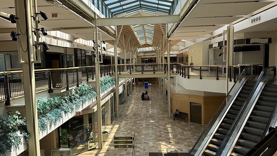 Exton Square MallExton, PA · 2020Partial Redeveloped · Reinhabited · Partial reinhabitation: healthcare, civic Partial redevelopment:…Granite Run MallMiddletown, PA · 2013Partial Redeveloped · Partial redevelopment: demalled plus residential435 Devon Park Dr.Wayne, PA · 2024Regreening · Reinhabitation, under construction · 162 apartments across the existing two-story buildings. Three acres…Abbey Gardens office complexReading, PAReinhabitation, approved · 92 apartments, made up of 84 one-bed and eight two-bed flatsAirport site (for large warehouse)Allentown, PARedevelopment, proposed · A large warehouse is proposed to be built