Malls · New York
Uncle Sam Atrium
Uncle Sam Atrium opened 1979 as a mall, struggled, converted to office/retail by 1994, now operating under Bryce Companies today. · summary, model-written
Solid = from the authors' map · outlined = public source · dashed = model-written, not yet reviewed by a person. Tap any value's source label to see where it came from. documented = a quoted excerpt (click to read it) · reported = a source named, no excerpt yet · no source.
Site profile13 elements · what this retrofit is built with · tap a chip for the evidence
15-minute neighbourhood (5+ of 6 daily needs within 800 m)
This site: 6/6 openstreetmap · all sites with this200+ tax-credit housing units within 1 km
This site: 486 units in 8 properties hud-lihtc · all sites with this3+ other atlas sites within 10 km
This site: 4 within 10 km computed · all sites with thisBike network nearby
This site: 28 ways openstreetmap · all sites with thisGrocery within 800 m
This site: 6 stores openstreetmap · all sites with thisHigh inland flooding risk
This site: Very High fema-nri · all sites with thisHigh social vulnerability tract (SVI ≥ 0.75)
This site: 0.87 cdc-svi · all sites with thisNational Register place within 500 m
This site: Proctor's Theater; National State Bank Building nps-nrhp · all sites with thisOpportunity Zone
This site: 36083040700 hud-oz · all sites with thisRenter-majority tract
This site: 89% census-acs · all sites with thisReinhabited
This site: Today, the mall along with the attached Frear Building is mostly occupied by office space and retail. extraction · all sites with thisOffice
This site: …long with the attached Frear Building is mostly occupied by office space and retail. extraction · all sites with thisRetail (continued)
This site: …ached Frear Building is mostly occupied by office space and retail. extraction · all sites with thisNow
| Status | Operatingextracted, unreviewed documentedToday, the mall along with the attached Frear Building is mostly occupied by office space and retail. |
|---|---|
| Strategy | Reinhabitedextracted, unreviewed documentedBeginning in 1994, retail space in the Uncle Sam Atrium was converted to office space for New York State agencies |
| New uses | office, retailextracted, unreviewed reported |
| What is there now | Today, the mall along with the attached Frear Building is mostly occupied by office space and retail.extracted, unreviewed documentedToday, the mall along with the attached Frear Building is mostly occupied by office space and retail. |
| Retrofit year | 1994extracted, unreviewed reported |
Deals and debt
| Date | Event | Price | Parties | Source |
|---|---|---|---|---|
| 1999 | Sold | — | David Bryce | Wikipedia |
Site context
| FEMA flood zone | no NFHL polygon at point (unmapped or outside coverage)FEMA NFHL |
|---|---|
| EPA-regulated facilities within 500 m | 38: ALBANY YACHT CLUB; BRIDGESTONE FIRESTONE; CAPITAL DISTRICT EDUCATIONAL OPPORTUNITY; CVS PHARMACY #0344 FORMER; DAN LEVESQUE AUTO BODY OF TROYEPA FRS |
| Census tract 36083040701 | 3,496 people, 10,133 per sq mi; median household income $56,125; median gross rent $1,235; 89% renters; 31.0% vacant units; 7.2% commute by transitACS 2023 5-year |
| Within a 10–15 minute walk (800 m) | 6 of 6 daily needs: 6 grocers, 6 schools, 27 parks or playgrounds, 5 health, 20 civic, 85 food and drink; 28 cycleway segments, 221 sidewalk-tagged segmentsOpenStreetMap |
| Opportunity Zone | yes, tract 36083040700 (rural)HUD |
| National Register places within 500 m | 12: Proctor's Theater; National State Bank Building; Cannon Building; Hart-Cluett MansionNPS |
| Housing permits, Rensselaer County (NY), 2024 | 131 units in 5+ unit buildings, 29 in 2–4, 160 single-family; 2023: 156 in 5+Census BPS |
| Social vulnerability (CDC SVI 2022, tract) | overall percentile 0.87; socioeconomic 0.81; housing and transport 0.92; 41% below 150% of poverty; 25% of households with no vehicleCDC/ATSDR |
| Other atlas sites nearby | 4 within 10 km, 8 within 25 km: 5-story vacant warehouse (0.4 km); Cohoes Commons (5.0 km); Latham Circle Mall (6.3 km); Albany Felt Company Complex (7.0 km)computed |
| Overture Maps | no place match; building footprint 4,600 m²Overture (CDLA-Permissive 2.0) |
| Attention: Wikipedia page views | 8,110 since 2015; 1,451 in the last 12 months (-10% vs the prior 12); peak 2025-11 with 247Wikimedia |
| Tract change 2013–2023 | tract boundary changed between the 2010 and 2020 census; no 2013 comparisonCensus ACS |
| Natural hazard risk (FEMA National Risk Index, tract) | relatively moderate overall (score 83.3); expected annual loss $2.3M; high: inland flooding; community resilience very highFEMA NRI |
| Tax-credit housing within 1 km | 8 LIHTC properties, 486 units: John F Kennedy Towers Senior Housing (135 units); River'S Edge Apts (128 units); O'Neil Apartments (123 units)HUD LIHTC |
| Retail trade in the county, 2025 (BLS QCEW) | 5,713 jobs in 413 establishments; average annual pay $39,746; employment location quotient 1.03; employment +0.5% on the yearBLS QCEW 2025, NAICS 44-45, private |
| Jobs located in the tract, 2022 | 6,578 jobs; 323 in retail trade, 680 in accommodation and food (workplace blocks summed to tract 36083040701)Census LEHD LODES8 WAC 2022 |
| Upward mobility (Opportunity Atlas, 2010 tract) | children of low-income (25th percentile) families reached the 35th income percentile as adults; 4.1% incarcerated at the 2010 count (449 children in the sample); born 1978–83, measured 2014–15Opportunity Insights |
| Food access (USDA FARA 2019, 2010 tract) | not a low-access tract at 1 mile; 8% of residents more than 1 mile from a supermarket; poverty rate 34.7%; median family income $40,278; 800 SNAP householdsUSDA ERS |
| Schools | Troy City School District (PK-12); 2 public schools within 1 mile: HEATLY SCHOOL; TROY MIDDLE SCHOOLNCES EDGE |
| Elevation | 34 ft above sea level at the site pointUSGS 3DEP |
| Storm events in the county, 2016-2025 | 248 county-logged events: 195 thunderstorm wind, 19 flash flood, 15 flood, 13 hail; $3,961,000 property damage reported; forecast-zone events (most flood, winter and heat) not countedNOAA Storm Events |
| Homes for sale in ZIP 12180, 2026-09 | median list price $357,425 (+22.5% on the year); 51 active listings; median 34 days on market; 12% with a price cutRealtor.com Research |
| Retail trade in the county, 2012 to 2023 | 435 establishments (+3%); 5,717 jobs (-4%)Census CBP |
| Housing market in the county | typical home value $327,950 (+6% 1 yr, +32% 5 yr); typical rent $1,521/mo (+6% 1 yr), 2026-09Zillow Research |
| Traffic on the busiest road within 600 m (2024) | 12,453 vehicles a day on Green Island Bridge (minor arterial); 488 trucks; 29 counted segmentsFHWA HPMS |
Summary, model-written
The Uncle Sam Atrium opened in 1979 as a shopping mall in downtown Troy. By the early 1990s it had become underutilized and mostly vacant due to its small size, Troy's population loss, and competition from larger suburban malls. Starting in 1994, retail space was converted to office use, and after being sold to David Bryce in 1999 the property is now mostly office and retail.
Why. The record cites the mall's small size, the city's population loss, and competition from nearby larger suburban malls as reasons for its early underutilization and vacancy.
Where it stands. The site is currently operating and is controlled by Bryce Companies, which acquired the property in a 1999 sale to David Bryce.
For a planner
- Strategy listed as "reinhabit" with retrofit completed in 1994.
- No public policy tools or incentives are mentioned in the record.
- Open questions include long-term office demand and potential for further adaptive reuse.
For a developer
- Site size and parcel boundaries are not provided in the record.
- Ownership is clear (Bryce Companies) and the retrofit entitlements are already in place (office conversion completed 1994).
- Context-layer constraints such as flood risk, transit access, or environmental factors are not stated.
What we do not know yet
- Site size, parcel count, and exact building footprint are missing.
- Current vacancy rates, lease terms, and tenant mix are not detailed.
- Flood zone, transit proximity, and environmental constraints are absent from the record.
- The record is marked as "draft" verified, indicating some fields may be model-extracted and unreviewed.
Generated by nvidia/nemotron-3-super-120b-a12b on NVIDIA API via Hermes CT from the fields, parcels, deals and context layers on this page, with no outside knowledge. It is regenerated when the record changes and has not been checked by a person. How it is made.
Similar sites
- Cohoes Commons, Cohoes, NY · Malls · same strategy: reinhabit; also in NY; 5 km away
- Penn-Can Mall, Cicero, NY · Malls · opened 1976; same strategy: reinhabit; also in NY
- Summit Park Mall, Wheatfield, NY · Malls · opened 1972; same strategy: reinhabit; also in NY
- Arecibo Mall, Arecibo · Malls · opened 1981; same strategy: reinhabit
Elsewhere on the web
Pages with photos
- Troy New York farmers marke… alamy.com
- Bonhams : James Crable (American, 1909-2002); Uncle Sam Atrium, Troy ... bonhams.com
- The Uncle Sam Atrium – Szöveges kalandjáték interactivefiction.hu
Search images: Google · Bing · Commons · references: ULI case studies · Google Scholar
Multifamily screen
- retrofit already built
Inputs: record fields (size, status) and county Census ACS 2018–2023 figures (growth, rent). How the points work. Not a recommendation.
History and original facts
| Opened | 1979extracted, unreviewed |
|---|---|
| Original developer | Carl Grimmextracted, unreviewed documentedIt was not until 1976 that local developer Carl Grimm had taken up the project. |
| Architect | Geoffrey Freeman Associates |
| Anchors | Denby's, Carl Company |
| County | Rensselaer County |
| Census division | 2 · Mid-Atlantic |
| Notes | Wikipedia categories: Defunct shopping malls in the United States |
Not yet recorded: acres, GLA. Know it? Tell us.
Background
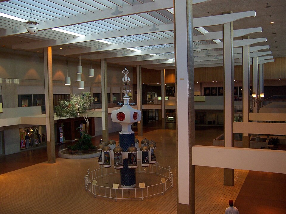
The Uncle Sam Atrium and Parking Garage is an urban office space, and parking garage in downtown Troy, New York,. Originally envisioned as a much larger $96 million shopping mall in the early 1970s, the project stagnated due to financial problems until local developer Carl Grimm put forth the financing to complete a smaller shopping center. Due to its small size, Troy's population loss, and competition from nearby larger suburban malls, the Uncle Sam Atrium became underutilized and mostly vacant by the early 1990s. In the late 1990s and 2000s, the mall was bought by David Bryce and saw most of its retail space converted to offices for the New York State Department of Health and Department of Labor. Today, the mall along with the attached Frear Building is mostly occupied by office space and retail.
Excerpt from Wikipedia (authors and history), CC BY-SA 4.0. May be older than the record above.
Timeline
- 1969 Idea for a large shopping mall to revitalize downtown Troy first presented
- 1973 Demolition for Phase One started
- 1976 Local developer Carl Grimm took up the project
- 1977 Broke ground on the mall
- 1979 Mall opened
- 1994 Conversion of retail space to office space began
- 1999 David Bryce bought the mall
- 2020 Farmer's market moved due to COVID-19 pandemic
Sources
- Wikipedia: Uncle Sam Atrium · supports: after notes, original developer, status, strategy, year opened
13 quoted sentences
The Uncle Sam Atrium broke ground in 1977 and opened in 1979.
It was not until 1976 that local developer Carl Grimm had taken up the project.
Today, the mall along with the attached Frear Building is mostly occupied by office space and retail.
Today, the mall along with the attached Frear Building is mostly occupied by office space and retail.
More in New York
 Midtown PlazaRochester, NY · 2005Partial Redeveloped · Regreened · Reinhabited · Partial reinhabitation: residential Partial redevelopment: office…Rainbow MallNiagara Falls, NY · 2012Partial Reinhabited · Partial reinhabitation: education