Malls · New York
Seneca Mall
Seneca Mall opened 1969 in West Seneca, NY; known as The Shops at West Seneca; current status and control unknown. · summary, model-written
Solid = from the authors' map · outlined = public source · dashed = model-written, not yet reviewed by a person. Tap any value's source label to see where it came from. documented = a quoted excerpt (click to read it) · reported = a source named, no excerpt yet · no source.
Site profile8 elements · what this retrofit is built with · tap a chip for the evidence
15-minute neighbourhood (5+ of 6 daily needs within 800 m)
This site: 6/6 openstreetmap · all sites with this3+ other atlas sites within 10 km
This site: 3 within 10 km computed · all sites with this30,000+ vehicles a day on an adjacent road
This site: 107,743 on NYS Thruway fhwa-hpms · all sites with thisBike network nearby
This site: 24 ways openstreetmap · all sites with thisGrocery within 800 m
This site: 5 stores openstreetmap · all sites with thisHigh inland flooding risk
This site: Relatively High fema-nri · all sites with thisTract house prices doubled in 10 years
This site: +106% fhfa · all sites with thisWalkable block group (EPA ≥ 12)
This site: …index 13 epa-walkability · all sites with thisNow
| Status | Status not verifiedWikidata reported |
|---|
Site context
| Transit within 800 m | no rail stationOpenStreetMap |
|---|---|
| Motorway junctions within 2 km | 54, 55, junctionOpenStreetMap |
| FEMA flood zone | X · AREA OF MINIMAL FLOOD HAZARDFEMA NFHL |
| EPA-regulated facilities within 500 m | 12: DELTA SONIC - WEST SENECA; EBENEZER BUILDING; FIRESTONE TIRE & SERVICE CENTER; GOODYEAR AUTO SERVICE CENTER; HOME DEPOT USA INC HD1231EPA FRS |
| Census tract 36029012001 | 4,980 people, 1,972 per sq mi; median household income $87,862; median gross rent $799; 11% renters; 1.5% vacant units; 0.0% commute by transitACS 2023 5-year |
| Walkability (EPA, block group) | index 13 of 20; 14 intersections per sq mi; nearest transit stop 727 m; land-use mix 0.85; 72,426 jobs within 45 min by car, 12,541 by transit; 0% of households without a carEPA Smart Location |
| Within a 10–15 minute walk (800 m) | 6 of 6 daily needs: 5 grocers, 2 schools, 1 parks or playgrounds, 1 health, 1 civic, 3 food and drink; 24 cycleway segments, 0 sidewalk-tagged segmentsOpenStreetMap |
| Opportunity Zone | noHUD |
| Housing permits, Erie County (NY), 2024 | 578 units in 5+ unit buildings, 46 in 2–4, 584 single-family; 2023: 404 in 5+Census BPS |
| Social vulnerability (CDC SVI 2022, tract) | overall percentile 0.27; socioeconomic 0.39; housing and transport 0.13; 17% below 150% of poverty; 3% of households with no vehicleCDC/ATSDR |
| Other atlas sites nearby | 3 within 10 km, 5 within 25 km: Como Mall (7.1 km); J. N. Adam–AM&A Historic District (9.2 km); Main Place Mall (9.3 km)computed |
| Overture Maps | no place match; building footprint 8,648 m², 6.233434677124023 mOverture (CDLA-Permissive 2.0) |
| Attention: Wikipedia page views | 12,114 since 2015; 1,981 in the last 12 months (-8% vs the prior 12); peak 2026-07 with 520Wikimedia |
| Tract change 2013–2023 | population +19% (4,187 → 4,980); median income +51% ($58,108 → $87,862); renters 19% → 11%; median home value +75% ($117,300 → $205,700)Census ACS 5-year |
| Natural hazard risk (FEMA National Risk Index, tract) | relatively moderate overall (score 65.3); expected annual loss $1.8M; high: inland flooding, winter weather, cold wave; community resilience very highFEMA NRI |
| Tax-credit housing within 1 km | noneHUD LIHTC |
| Retail trade in the county, 2025 (BLS QCEW) | 47,627 jobs in 2,834 establishments; average annual pay $41,000; employment location quotient 1.04; employment -0.6% on the yearBLS QCEW 2025, NAICS 44-45, private |
| Jobs located in the tract, 2022 | 1,499 jobs; 533 in retail trade, 133 in accommodation and food (workplace blocks summed to tract 36029012001)Census LEHD LODES8 WAC 2022 |
| Upward mobility (Opportunity Atlas, 2010 tract) | children of low-income (25th percentile) families reached the 49th income percentile as adults; -0.0% incarcerated at the 2010 count (252 children in the sample); born 1978–83, measured 2014–15Opportunity Insights |
| Food access (USDA FARA 2019, 2010 tract) | not a low-access tract at 1 mile; 7% of residents more than 1 mile from a supermarket; poverty rate 6.0%; median family income $98,946; 141 SNAP householdsUSDA ERS |
| Schools | West Seneca Central School District (PK-12); 3 public schools within 1 mile: WEST MIDDLE SCHOOL; WEST SENECA WEST SENIOR HIGH SCHOOL; WINCHESTER-POTTERS ELEMENTARY SCHOOLNCES EDGE |
| Elevation | 615 ft above sea level at the site pointUSGS 3DEP |
| Storm events in the county, 2016-2025 | 278 county-logged events: 167 thunderstorm wind, 32 hail, 28 flash flood, 23 flood; $1,702,400 property damage reported; forecast-zone events (most flood, winter and heat) not countedNOAA Storm Events |
| Homes for sale in ZIP 14224, 2026-09 | median list price $329,450 (+14.1% on the year); 46 active listings; median 43 days on market; 14% with a price cutRealtor.com Research |
| Retail trade in the county, 2012 to 2023 | 3,116 establishments (-7%); 49,839 jobs (-6%)Census CBP |
| Housing market in the county | typical home value $295,625 (+3% 1 yr, +31% 5 yr); typical rent $1,480/mo (+4% 1 yr), 2026-09Zillow Research |
| House price index, tract, 2025 | 485 (2000 = 100); +5.6% 1 yr, +61% 5 yr, +106% 10 yrFHFA |
| Traffic on the busiest road within 600 m (2024) | 107,743 vehicles a day on NYS Thruway; 14,313 trucks; 40 counted segmentsFHWA HPMS |
Summary, model-written
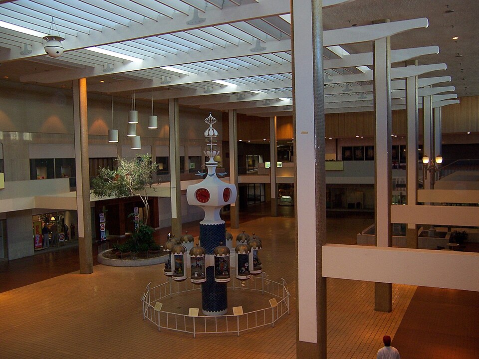
Seneca Mall opened in 1969 as an enclosed shopping mall at Ridge Road and Slade Avenue in West Seneca, NY. It was later referred to as The Shops at West Seneca. The record does not provide further details about its subsequent operations or closure.
Why. not stated in the record
Where it stands. The site's current status is unknown and no controlling owner is identified in the record.
For a planner
- The mall opened in 1969 and is located at a major intersection near the New York State Thruway.
- No information on zoning, land‑use policies, or prior reuse attempts is provided.
- Open questions include ownership, potential redevelopment pathways, and any existing entitlements.
For a developer
- Site size and parcel boundaries are not specified in the record.
- Control and ownership of the property are unknown, affecting acquisition feasibility.
- No context‑layer data (flood risk, transit access, environmental constraints) or market signals are available.
What we do not know yet
- Current operational status (open, vacant, demolished) is unknown.
- Ownership entity and any deed restrictions are not provided.
- Reasons for any decline or closure are not stated in the record.
- Site dimensions, parcel count, and exact location details are missing.
- No data on flood plains, transit proximity, environmental conditions, or local market trends are included.
Generated by nvidia/nemotron-3-super-120b-a12b on NVIDIA API via Hermes CT from the fields, parcels, deals and context layers on this page, with no outside knowledge. It is regenerated when the record changes and has not been checked by a person. How it is made.
Similar sites
- Summit Park Mall, Wheatfield, NY · Malls · opened 1972; also in NY; 31 km away
- Main Place Mall, Buffalo, NY · Malls · opened 1968; also in NY; 9 km away
- Boulevard Mall, Erie County, NY · Malls · opened 1962; also in NY; 18 km away
- Eastern Hills Mall, Clarence, NY · Malls · opened 1971; also in NY; 17 km away
Elsewhere on the web
Retail history: Seneca Mall on DeadMalls.com photos, field notes and visitor memories since 2000; matched by name and state only, check the city; nothing copied here
Pages with photos
- Seneca Mall - Buffalo Stories Archives & Blog blog.buffalostories.com
- Seneca Mall Cinema in West Seneca, N… cinematreasures.org
- Plans to redevelop former Seneca Mall site wgrz.com
- 'It's a wasteland': Calls for redevelopment of former Seneca Mall site wkbw.com
- Former Seneca Mall site sold for nearly $22 million buffalonews.com
- Seneca Mall "Renovation Celebration" Commercia… youtube.com
- Former Seneca Mall: Why hasn't Pyramid redeveloped the vacant si… bizjournals.com
Search images: Google · Bing · Commons · references: ULI case studies · Google Scholar
Multifamily screen
- county grew 3.3% 2018–23
Inputs: record fields (size, status) and county Census ACS 2018–2023 figures (growth, rent). How the points work. Not a recommendation.
History and original facts
| Opened | 1969extracted, unreviewed |
|---|---|
| County | Erie County |
| Census division | 2 · Mid-Atlantic |
| Notes | Wikipedia categories: Demolished shopping malls in the United States |
Not yet recorded: acres, GLA, original developer, what is there now, retrofit year. Know it? Tell us.
Background
The Shops at West Seneca was a shopping mall south of Buffalo, New York, United States. Built in 1969 as an enclosed shopping mall called Seneca Mall, it is in the Town of West Seneca at the intersection of Ridge Road and Slade Avenue immediately east of the New York State Thruway.
Excerpt from Wikipedia (authors and history), CC BY-SA 4.0. May be older than the record above.
Sources
- Wikipedia: Seneca Mall · supports: year opened
1 quoted sentence
Built in 1969
More in New York
 Midtown PlazaRochester, NY · 2005Partial Redeveloped · Regreened · Reinhabited · Partial reinhabitation: residential Partial redevelopment: office…Rainbow MallNiagara Falls, NY · 2012Partial Reinhabited · Partial reinhabitation: education