Malls · Minnesota
Oakdale Mall
Redeveloped · Regreened in 2012. · from the fields below
Solid = from the authors' map · outlined = public source · dashed = model-written, not yet reviewed by a person. Tap any value's source label to see where it came from. documented = a quoted excerpt (click to read it) · reported = a source named, no excerpt yet · no source.
Site profile15 elements · what this retrofit is built with · tap a chip for the evidence
100k+ jobs within 45 min by transit
This site: 118,049 epa-walkability · all sites with this15-minute neighbourhood (5+ of 6 daily needs within 800 m)
This site: 5/6 openstreetmap · all sites with this3+ other atlas sites within 10 km
This site: 3 within 10 km computed · all sites with this30,000+ vehicles a day on an adjacent road
This site: 83,373 on 694 fhwa-hpms · all sites with thisBike network nearby
This site: 35 ways openstreetmap · all sites with thisCounty typical rent $2,000+
This site: $2,000/mo zillow · all sites with thisGrocery within 800 m
This site: 2 stores openstreetmap · all sites with thisHigh social vulnerability tract (SVI ≥ 0.75)
This site: 0.80 cdc-svi · all sites with thisHigh tornado risk
This site: Relatively High fema-nri · all sites with thisInterstate or freeway within 600 m
This site: 694 fhwa-hpms · all sites with thisRenter-majority tract
This site: 51% census-acs · all sites with thisRedeveloped
This site: Redevelopment: retail, senior residential Partial regreening: retention pond arcgis-webmap · all sites with thisRegreened
This site: Redevelopment: retail, senior residential Partial regreening: retention pond arcgis-webmap · all sites with thisHousing
This site: Redevelopment: retail, senior residential Partial regreening: retention pond arcgis-webmap · all sites with thisRetail (continued)
This site: Redevelopment: retail, senior residential Partial regreening: retention pond arcgis-webmap · all sites with thisFrom the authors' map
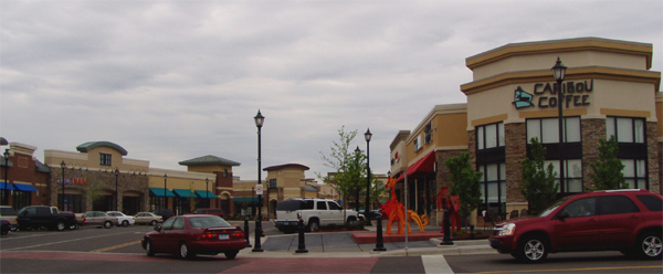
MN, Oakdale: Oakdale Mall/Tartan Crossing, 2012
• Redevelopment: retail, senior residential
• Partial regreening: retention pond
Now
| Status | Retrofit builtderived from authors' map (retrofit year present) reported |
|---|---|
| Strategy | Redeveloped · Regreenedauthors' map reported |
| What is there now | Redevelopment: retail, senior residential Partial regreening: retention pondauthors' map reported |
| Retrofit year | 2012authors' map reported |
Securitised debt and public filers
Filings (2001 to date) that name “Oakdale Mall” and “Oakdale” (66 hits, first 66 sampled, 8 other filers such as tenants left out). No commercial-mortgage trust names this mall in the sample, which does not rule out a securitised loan. Text matches, not a title search. Open the search · all trusts.
| Kind | Filer | Filings | Dates | Forms |
|---|---|---|---|---|
| Public owner | Seritage Growth Properties (SRG, SRG-PA) | 4 | 2016-03-11 to 2019-03-01 | 10-K 4 |
Site context
| FEMA flood zone | X · AREA OF MINIMAL FLOOD HAZARDFEMA NFHL |
|---|---|
| EPA-regulated facilities within 500 m | 17: ALL FAMILY DENTAL; ALL FAMILY DENTAL LTD; ALL SMALL CRITTERS PET CLINIC; ANIMAL EMERGENCY CLINIC - 10T; BARTLETT CHIROPRACTICEPA FRS |
| Census tract 27163070912 | 3,034 people, 4,759 per sq mi; median household income $53,015; median gross rent $1,481; 51% renters; 5.3% vacant units; 5.3% commute by transitACS 2023 5-year |
| Walkability (EPA, block group) | index 10.7 of 20; 43 intersections per sq mi; nearest transit stop 464 m; land-use mix 0.56; 132,391 jobs within 45 min by car, 118,049 by transit; 9% of households without a carEPA Smart Location |
| Within a 10–15 minute walk (800 m) | 5 of 6 daily needs: 2 grocers, 1 schools, 10 parks or playgrounds, 0 health, 1 civic, 13 food and drink; 35 cycleway segments, 40 sidewalk-tagged segmentsOpenStreetMap |
| Opportunity Zone | noHUD |
| Housing permits, Washington County (MN), 2024 | 128 units in 5+ unit buildings, 8 in 2–4, 1,261 single-family; 2023: 1,060 in 5+Census BPS |
| Social vulnerability (CDC SVI 2022, tract) | overall percentile 0.80; socioeconomic 0.48; housing and transport 0.82; 23% below 150% of poverty; 19% of households with no vehicleCDC/ATSDR |
| Other atlas sites nearby | 3 within 10 km, 20 within 25 km: Lillie Redevelopment (5.8 km); Ponds at Battle Creek (8.1 km); Maplewood Mall (8.7 km)computed |
| Overture Maps | no place match; building footprint 8,416 m², 6.308234214782715 mOverture (CDLA-Permissive 2.0) |
| Tract change 2013–2023 | population -2% (3,095 → 3,034); median income +32% ($40,125 → $53,015); renters 48% → 51%; median home value +48% ($183,800 → $271,200)Census ACS 5-year |
| Natural hazard risk (FEMA National Risk Index, tract) | relatively low overall (score 21.6); expected annual loss $669,373; high: tornado, strong wind; community resilience very highFEMA NRI |
| Tax-credit housing within 1 km | noneHUD LIHTC |
| Retail trade in the county, 2025 (BLS QCEW) | 13,823 jobs in 684 establishments; average annual pay $36,917; employment location quotient 1.45; employment -5.5% on the yearBLS QCEW 2025, NAICS 44-45, private |
| Jobs located in the tract, 2022 | 1,318 jobs; 557 in retail trade, 248 in accommodation and food (workplace blocks summed to tract 27163070912)Census LEHD LODES8 WAC 2022 |
| Upward mobility (Opportunity Atlas, 2010 tract) | children of low-income (25th percentile) families reached the 45th income percentile as adults; 1.2% incarcerated at the 2010 count (267 children in the sample); born 1978–83, measured 2014–15Opportunity Insights |
| Food access (USDA FARA 2019, 2010 tract) | not a low-access tract at 1 mile; poverty rate 17.3%; median family income $58,571; 187 SNAP householdsUSDA ERS |
| Schools | North St. Paul-Maplewood-Oakdale School District (PK-12); 4 public schools within 1 mile: NE Metro Tartan; EAGLE POINT ELEMENTARY; TARTAN SENIOR HIGH; SKYVIEW COMMUNITY MIDDLENCES EDGE |
| Elevation | 1,082 ft above sea level at the site pointUSGS 3DEP |
| Storm events in the county, 2016-2025 | 118 county-logged events: 79 hail, 27 thunderstorm wind, 5 tornado, 4 heavy rain; $2,305,000 property damage reported; forecast-zone events (most flood, winter and heat) not countedNOAA Storm Events |
| Homes for sale in ZIP 55128, 2026-09 | median list price $298,675 (-0.4% on the year); 77 active listings; median 40 days on market; 26% with a price cutRealtor.com Research |
| Retail trade in the county, 2012 to 2023 | 699 establishments (-1%); 15,399 jobs (+22%)Census CBP |
| Housing market in the county | typical home value $445,711 (+3% 1 yr, +13% 5 yr); typical rent $2,000/mo (+4% 1 yr), 2026-09Zillow Research |
| House price index, tract, 2025 | 330 (2000 = 100); +6.5% 1 yr, +29% 5 yr, +67% 10 yrFHFA |
| Traffic on the busiest road within 600 m (2024) | 83,373 vehicles a day on 694 (Interstate, 4 lanes); 10,398 trucks; 20 counted segmentsFHWA HPMS |
Similar sites
- Brookdale Center, Brooklyn Center, MN · Malls · same strategy: redevelop; also in MN; 30 km away
- Former JCPenney building, Edina, MN · Malls · same strategy: redevelop; also in MN; 31 km away
- Maplewood Mall, Maplewood, MN · Malls · same strategy: regreen; also in MN; 9 km away
- One Southdale Place, Edina, MN · Other · same strategy: redevelop; also in MN; 30 km away
Elsewhere on the web
Pages with photos
- Some Oakdale Mall Businesses Prepare to R… wnbf.com
- What you need to know about the Oakdale Mall – … windowswear.com
- Do You Remember These Former Oakdale Mall Stores? 991thewhale.com
- Spark JC completes purchase of the Oakdale Mall | WIVT - News 34 binghamtonhomepage.com
- Oakdale Mall - a photo on Flickriver flickriver.com
- GALLERY: What We'd Like To See Go Into The Oakdale Mall 981thehawk.com
- Oakdale Mall finds new life with mixed concept spectrumlocalnews.com
Search images: Google · Bing · Commons · references: ULI case studies · Google Scholar
Multifamily screen
- retrofit already built
- county grew 7.5% 2018–23
- median rent $1,637
Inputs: record fields (size, status) and county Census ACS 2018–2023 figures (growth, rent). How the points work. Not a recommendation.
History and original facts
| Now called / also known as | Tartan Crossing |
|---|---|
| County | Washington County |
| Census division | 4 · West North Central |
Not yet recorded: acres, GLA, year opened, original developer. Know it? Tell us.
Timeline
- 2012 Retrofit: redevelop, regreen
Sources
More in Minnesota
 Apache PlazaSt. Anthony, MN · 2004Redeveloped · Silver Lake Village