Malls · Kentucky
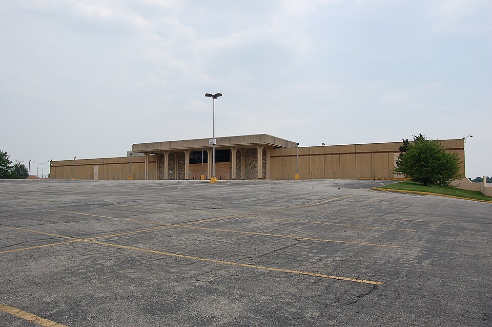
Lexington Mall
Opened 1974. Closed 2005. Reinhabited in 2013.
More
Solid = from the authors' map · outlined = public source · dashed = model-written, not yet reviewed by a person. Tap any value's source label to see where it came from. documented = a quoted excerpt (click to read it) · reported = a source named, no excerpt yet · no source.
Site profile13 elements · what this site is built with · tap a chip for the evidence
Dillard's
This site: Dillard's wikipedia · all sites with thisUniversity, hospital or church
This site: Southland Christian Church county-parcels · all sites with this15-minute neighbourhood (5+ of 6 daily needs within 800 m)
This site: 6/6 openstreetmap · all sites with this30,000+ vehicles a day on an adjacent road
This site: 56,977 on E NEW CIRCLE RD fhwa-hpms · all sites with thisBike network nearby
This site: 21 ways openstreetmap · all sites with thisGrocery within 800 m
This site: 3 stores openstreetmap · all sites with thisHigh tornado risk
This site: Relatively High fema-nri · all sites with thisInterstate or freeway within 600 m
This site: E NEW CIRCLE RD fhwa-hpms · all sites with thisLow social vulnerability tract (SVI ≤ 0.25)
This site: 0.25 cdc-svi · all sites with thisTract income flat or down since 2013
This site: -3% census-acs · all sites with thisWalkable block group (EPA ≥ 12)
This site: …index 12.8 epa-walkability · all sites with thisReinhabited
This site: Reinhabitation: religious record · all sites with thisChurch and worship
This site: …new_use field extraction · all sites with thisFrom the authors' map
KY, Lexington: Lexington Mall, Southland Christian Church, 2013
• Reinhabitation: religious
Now
| Status | Retrofit builtderived from authors' map (retrofit year present) reported |
|---|---|
| Strategy | Reinhabitedauthors' map reported |
| New uses | churchextracted, unreviewed reported |
| What is there now | Reinhabitation: religiousauthors' map reported |
| Retrofit year | 2013authors' map reported |
| Developer | Southland Christian Churchextracted, unreviewed |
Links out
Every link is built from an id this record holds (parcel number, filer CIK, Wikidata item, Census tract, coordinates) or from the name and city typed into a search. Nothing here is a guessed address. Search links are marked search in their source note; commercial listing links are marked for search engines not to follow. Hover a link for why it is here.
Official records (8)
government and regulatory records for this site, built from ids on the record
- EDGAR filer · Saul Centers Inc (Bfs, Bfs-Pd, Bfs-Pe)from sec.gov
- Filing 0001193125-10-058182 (10-Q, 10-K, 8-K, 10-K/A)from sec.gov
- EDGAR full-text search: “Lexington Mall”from city search
- Census tract 21067001700 profile (data.census.gov)from data.census.gov
- Census tract 21067001700 on Census Reporterfrom censusreporter.org
- Fayette (21067) profile (data.census.gov)from data.census.gov
- FEMA flood map (NFHL) at this point (search)from msc.fema.gov
- EPA ECHO facilities within 1 milefrom echo.epa.gov
Reference (6)
encyclopedic and research references
- Wikipedia articlefrom en.wikipedia.org
- Wikidata item Q6537834from wikidata.org
- Wikimedia Commons photos within 500 mfrom commons.wikimedia.org
- Authors' map layer on ArcGISfrom arcgis.com
- Retrofitting Suburbia (book site)from retrofittingsuburbia.com
- Lexington, Kentucky on Wikipediafrom en.wikipedia.org
Place (8)
map and street views by coordinates
- Google Mapsfrom google.com
- Street Viewfrom google.com
- Bing Mapsfrom bing.com
- Apple Mapsfrom maps.apple.com
- OpenStreetMapfrom openstreetmap.org
- Walk Score at this pointfrom walkscore.com
- Transitland mapfrom transit.land
- USGS National Mapfrom apps.nationalmap.gov
Market (2)
listings and owner pages; commercial, so search engines are told not to follow
- LoopNet: for sale in Lexington, KY (search)from city search
- DeadMalls.com · Lexington Mallfrom deadmalls.com
News (2)
news searches and archived pages
- Google News: “Lexington Mall” (search)from name search
- Bing News: “Lexington Mall” (search)from name search
History and original facts
| Now called / also known as | Southland Christian Church |
|---|---|
| Opened | 1974Esri 2014 layer |
| Closed | 2005extracted, unreviewed documentedThe mall's only remaining tenant, Dillard's left the mall in September 2005 to focus its operations at the Fayette Mall store. |
| Gross leasable area | 508,000 sq ftEsri 2014 layer reported |
| Stores at peak | 9Esri 2014 layer reported |
| Anchors | Dillard's, Home Depot, Border's Books, Wild Oats, McAlpin's, Shoppers Choice Supermarket, CSC discount store, County Market |
| Address | Richmond Rd. & New Circle Rd. |
| County | Fayette |
| Census division | 6 · East South Central |
Not yet recorded: acres, original developer. Know it? Tell us.
Planning
| No zoning change, subsidy or policy tool recorded for this site. |
Deals and debt
| Date | Event | Price | Parties | Source |
|---|---|---|---|---|
| 2010 | Sold | — | Southland Christian Church ← Saul Centers Inc | Wikipedia |
Securitised debt and public filers
Filings (2001 to date) that name “Lexington Mall” and “Lexington” (53 hits, first 53 sampled, 3 other filers such as tenants left out). No commercial-mortgage trust names this mall in the sample, which does not rule out a securitised loan. Text matches, not a title search. Open the search · all trusts.
| Kind | Filer | Filings | Dates | Forms |
|---|---|---|---|---|
| Public owner (strong) | SAUL CENTERS INC (BFS, BFS-PD, BFS-PE) | 47 | 2001-05-14 to 2010-03-16 | 10-Q 31, 10-K 8, 8-K 6, 10-K/A 2 |
Before and after
Before: the mall
| Renovations | 1993quote |
|---|
After: the retrofit
| Demolished | 2,011quote |
|---|
Hover "quote" to see the sentence each value came from. Planned figures are labelled planned. Method.
Site context
| FEMA flood zone | X · AREA OF MINIMAL FLOOD HAZARDFEMA NFHL |
|---|---|
| EPA-regulated facilities within 500 m | 28: 6TH STREET WATER MAIN REPLACEMENT; APPALACHIAN FUELS LLC (880-0180); ATHENS-BOONESBORO WATER LINE EXTENSION; CHEVRON USA, INC.; CHICK-FIL-A RICHMOND ROAD FSUEPA FRS |
| Census tract 21067001700 | 2,152 people, 2,298 per sq mi; median household income $56,149; median gross rent $935; 32% renters; 5.8% vacant units; 2.6% commute by transitACS 2023 5-year |
| Walkability (EPA, block group) | index 12.8 of 20; 22 intersections per sq mi; nearest transit stop 98 m; land-use mix 0.69; 62,715 jobs within 45 min by car, 48,661 by transit; 6% of households without a carEPA Smart Location |
| Within a 10–15 minute walk (800 m) | 6 of 6 daily needs: 3 grocers, 2 schools, 12 parks or playgrounds, 1 health, 1 civic, 13 food and drink; 21 cycleway segments, 8 sidewalk-tagged segmentsOpenStreetMap |
| Opportunity Zone | noHUD |
| Housing permits, Fayette County (KY), 2024 | 542 units in 5+ unit buildings, 2 in 2–4, 492 single-family; 2023: 768 in 5+Census BPS |
| Social vulnerability (CDC SVI 2022, tract) | overall percentile 0.25; socioeconomic 0.32; housing and transport 0.16; 21% below 150% of poverty; 8% of households with no vehicleCDC/ATSDR |
| Other atlas sites nearby | 1 within 10 km, 2 within 25 km: Turfland Mall (7.0 km)computed |
| Overture Maps | no place match; building footprint 11,201 m², 6.734344482421875 mOverture (CDLA-Permissive 2.0) |
| Attention: Wikipedia page views | 32,244 since 2015; 2,672 in the last 12 months (-14% vs the prior 12); peak 2024-11 with 436Wikimedia |
| Tract change 2013–2023 | population +9% (1,977 → 2,152); median income -3% ($57,650 → $56,149); renters 43% → 32%; median home value +40% ($260,100 → $365,500)Census ACS 5-year |
| Natural hazard risk (FEMA National Risk Index, tract) | relatively low overall (score 35.2); expected annual loss $862,390; high: tornado; community resilience relatively highFEMA NRI |
| Tax-credit housing within 1 km | noneHUD LIHTC |
| Retail trade in the county, 2025 (BLS QCEW) | 19,778 jobs in 1,370 establishments; average annual pay $40,673; employment location quotient 0.97; employment +1.0% on the yearBLS QCEW 2025, NAICS 44-45, private |
| Jobs located in the tract, 2022 | 1,489 jobs; 508 in retail trade, 140 in accommodation and food (workplace blocks summed to tract 21067001700)Census LEHD LODES8 WAC 2022 |
| Upward mobility (Opportunity Atlas, 2010 tract) | children of low-income (25th percentile) families reached the 43rd income percentile as adults; 1.7% incarcerated at the 2010 count (233 children in the sample); born 1978–83, measured 2014–15Opportunity Insights |
| Food access (USDA FARA 2019, 2010 tract) | low-access at 1 mile, not low-income; 44% of residents more than 1 mile from a supermarket; poverty rate 13.0%; median family income $100,938; 71 SNAP householdsUSDA ERS |
| Schools | Fayette County School District (PK-12); 4 public schools within 1 mile: Henry Clay High School; Madeline M Breckinridge Elem School; Eastside Technical Center; Martin L King Acad for Excellence AltNCES EDGE |
| Elevation | 990 ft above sea level at the site pointUSGS 3DEP |
| Storm events in the county, 2016-2025 | 141 county-logged events: 96 thunderstorm wind, 17 flash flood, 15 hail, 6 lightning; $8,411,000 property damage reported; forecast-zone events (most flood, winter and heat) not countedNOAA Storm Events |
| Homes for sale in ZIP 40502, 2026-09 | median list price $722,000 (+4.7% on the year); 66 active listings; median 49 days on market; 27% with a price cutRealtor.com Research |
| Retail trade in the county, 2012 to 2023 | 1,173 establishments (-2%); 20,244 jobs (+2%)Census CBP |
| Housing market in the county | typical home value $330,784 (+3% 1 yr, +33% 5 yr); typical rent $1,628/mo (+4% 1 yr), 2026-09Zillow Research |
| House price index, tract, 2025 | 578 (2000 = 100); -2.8% 1 yr, +55% 5 yr, +94% 10 yrFHFA |
| Traffic on the busiest road within 600 m (2024) | 56,977 vehicles a day on E NEW CIRCLE RD (freeway or expressway, 4 lanes); 2,737 trucks; 31 counted segmentsFHWA HPMS |
Similar sites
- Turfland Mall, Lexington, KY · Malls · similar GLA (552,000 sq ft); opened 1967; closed 2008
- Dutchess Mall, Fishkill, NY · Malls · similar GLA (580,000 sq ft); opened 1974; closed 2001
- Kildonan Place, Winnipeg · Malls · similar GLA (460,498 sq ft); opened 1980; same strategy: reinhabit
- Prestonwood Mall, Dallas, TX · Malls · similar GLA (462,277 sq ft); opened 1979; closed 2004
Elsewhere on the web
Retail history: Lexington Mall on DeadMalls.com photos, field notes and visitor memories since 2000; matched by name and city; nothing copied here
Pages with photos
- Lexington Mall abandonedonline.net
- SOUTHLAND CHRISTIAN CHURCH - LEXINGTON C… yelp.com
- Unusual Kentucky: Goodbye, Lexington Mall unusualkentucky.blogspot.com
- Category:Southland Christian Church (Lexington, Kentucky) - Wikimedia ... commons.wikimedia.org
Search images: Google · Bing · Commons · references: ULI case studies · Google Scholar
Multifamily screen
- retrofit already built
- 508,000 sq ft GLA (large site)
Inputs: record fields (size, status) and county Census ACS 2018–2023 figures (growth, rent). How the points work. Not a recommendation.
Background
Lexington Mall was a small shopping mall located in Lexington, Kentucky along US 25/US 421. The mall portion was built in 1975.
Excerpt from Wikipedia (authors and history), CC BY-SA 4.0. May be older than the record above.
Timeline
- 1971 Original opening of anchor stores
- 1974 Opened
- 1975 Mall completed and opened
- 1984 County Market expands into former CSC
- 1988 Karmelkorn Shoppe national sales leader
- 1993 McAlpin's renovation
- 1995 County Market closes
- 2005 Dillard's departs
- 2010 Southland Christian Church purchases mall
- 2011 Demolition begins
- 2013 Retrofit: reinhabit
- 2013 New church opens
Sources
- Wikipedia: Lexington Mall · supports: year closed
11 quoted sentences
The mall's only remaining tenant, Dillard's left the mall in September 2005 to focus its operations at the Fayette Mall store.
It originally opened with a 2-story McAlpin's, Shoppers Choice Supermarket and a CSC discount store in 1971; however, the enclosed mall portion was not completed due to the bankruptcy of its primary developers.
In 1975, the remainder of the mall was completed and opened with 48 stores.
County Market replaced Shoppers Choice Supermarket in the 1980s, eventually expanding into the former CSC in 1984.
- Esri StoryMaps: Closed_US_Malls feature layer (2014) · 2014-10-02
- Retrofitting Suburbia Interactive Mall Map (ArcGIS web map ce33ab26…) · 2021-01-20