Malls · Texas
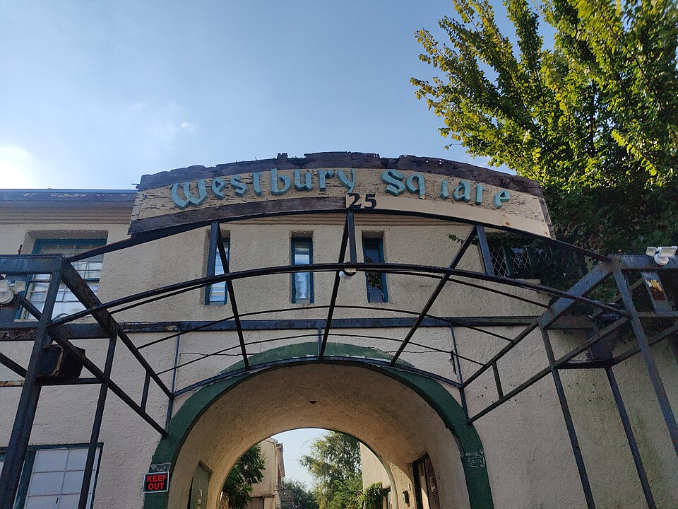
Westbury Square
Opened 1962. Redevelopment, proposed.
documented
On July 2, 2015, it was announced that the remaining buildings will be demolished and the site used for a gated community of approximately 110 homes.
documented
Westbury Square was a shopping center located on a 7.5-acre (3.0 ha) site near the intersection of Chimney Rock Road and West Bellfort Avenue, in the Westbury neighborhood in the Brays Oaks district of Southwest Houston, Texas.
Solid = from the authors' map · outlined = public source · dashed = model-written, not yet reviewed by a person. Tap any value's source label to see where it came from. documented = a quoted excerpt (click to read it) · reported = a source named, no excerpt yet · no source.
Site profile15 elements · what this retrofit is built with · tap a chip for the evidence
On Facebook
This site: …https://www.facebook.com/121506114564583 overture · all sites with thisRetrofit in the pipeline
This site: …proposed extraction · all sites with this15-minute neighbourhood (5+ of 6 daily needs within 800 m)
This site: 6/6 openstreetmap · all sites with this3+ other atlas sites within 10 km
This site: 3 within 10 km computed · all sites with thisBike network nearby
This site: 32 ways openstreetmap · all sites with thisCounty permitting 2,000+ apartment units a year
This site: 8,623 units, Harris County census-bps · all sites with thisGrocery within 800 m
This site: 4 stores openstreetmap · all sites with thisHigh inland flooding risk
This site: Relatively High fema-nri · all sites with thisHigh natural hazard risk (FEMA NRI)
This site: Relatively High; tornado, inland flooding fema-nri · all sites with thisHigh tornado risk
This site: Relatively High fema-nri · all sites with thisTract income up 60%+ since 2013
This site: +101% census-acs · all sites with thisWalkable block group (EPA ≥ 12)
This site: …index 14.3 epa-walkability · all sites with thisUnder 20 acres
This site: 7.5 acres extraction · all sites with thisRedeveloped
This site: …remaining buildings extraction · all sites with thisHousing
This site: …new_use field extraction · all sites with thisNow
| Status | Retrofit proposedextracted, unreviewed documentedOn July 2, 2015, it was announced that the remaining buildings will be demolished and the site used for a gated community of approximately 110 homes. |
|---|---|
| Strategy | Redevelopment, proposedextracted, unreviewed documentedOn July 2, 2015, it was announced that the remaining buildings will be demolished and the site used for a gated community of approximately 110 homes. |
| New uses | housingextracted, unreviewed reported |
| What is there now | remaining buildingsextracted, unreviewed |
Planning
| Planning notes | On July 2, 2015, it was announced that the remaining buildings will be demolished and the site used for a gated community of approximately 110 homes.extracted, unreviewed reported |
|---|
Securitised debt and public filers
Filings (2001 to date) that name “Westbury Square” and “Houston” (2 hits, first 2 sampled, 1 other filers such as tenants left out). No commercial-mortgage trust names this mall in the sample, which does not rule out a securitised loan. Text matches, not a title search. Open the search · all trusts.
| Kind | Filer | Filings | Dates | Forms |
|---|---|---|---|---|
| Public owner (weak) | Moody National REIT I, Inc. | 1 | 2012-08-20 to 2012-08-20 | 8-K 1 |
Site context
| Transit within 800 m | no rail stationOpenStreetMap |
|---|---|
| Motorway junctions within 2 km | junctionOpenStreetMap |
| FEMA flood zone | X · AREA OF MINIMAL FLOOD HAZARDFEMA NFHL |
| EPA-regulated facilities within 500 m | 6: BRIDENT DENTAL; HOME DEPOT STORE 578; LIBERTY CLEANERS; MEYERLAND AUTOMOTIVE CENTER INC; MILLION CLEANERSEPA FRS |
| Census tract 48201422100 | 5,227 people, 5,643 per sq mi; median household income $99,199; median gross rent $1,872; 18% renters; 7.7% vacant units; 0.4% commute by transitACS 2023 5-year |
| Walkability (EPA, block group) | index 14.3 of 20; 217 intersections per sq mi; nearest transit stop 507 m; land-use mix 0.55; 331,023 jobs within 45 min by car, 82,574 by transit; 22% of households without a carEPA Smart Location |
| Within a 10–15 minute walk (800 m) | 6 of 6 daily needs: 4 grocers, 1 schools, 36 parks or playgrounds, 1 health, 3 civic, 7 food and drink; 32 cycleway segments, 157 sidewalk-tagged segmentsOpenStreetMap |
| Opportunity Zone | noHUD |
| Housing permits, Harris County (TX), 2024 | 8,623 units in 5+ unit buildings, 1,226 in 2–4, 20,087 single-family; 2023: 13,263 in 5+Census BPS |
| Social vulnerability (CDC SVI 2022, tract) | overall percentile 0.69; socioeconomic 0.57; housing and transport 0.31; 24% below 150% of poverty; 9% of households with no vehicleCDC/ATSDR |
| Other atlas sites nearby | 3 within 10 km, 18 within 25 km: Westwood Mall (6.6 km); Sharpstown Mall (6.6 km); Blair House (6.8 km)computed |
| Overture Maps | place Westbury Square Cigar Shop (tobacco_shop, confidence 0.59, from Overture, meta); building footprint 10,051 m², 10.1 mOverture (CDLA-Permissive 2.0) |
| Website and social | no website listed · social: facebookOverture / Internet Archive |
| Attention: Wikipedia page views | 30,017 since 2015; 1,855 in the last 12 months (-19% vs the prior 12); peak 2020-01 with 2,448Wikimedia |
| Tract change 2013–2023 | population +4% (5,024 → 5,227); median income +101% ($49,348 → $99,199); renters 22% → 18%; median home value +75% ($134,800 → $236,100)Census ACS 5-year |
| Natural hazard risk (FEMA National Risk Index, tract) | relatively high overall (score 84.6); expected annual loss $3.4M; high: tornado, inland flooding; community resilience very lowFEMA NRI |
| Tax-credit housing within 1 km | 1 LIHTC properties, 75 units: Westbury Manor (75 units)HUD LIHTC |
| Retail trade in the county, 2025 (BLS QCEW) | 210,476 jobs in 13,134 establishments; average annual pay $44,568; employment location quotient 0.87; employment -0.8% on the yearBLS QCEW 2025, NAICS 44-45, private |
| Jobs located in the tract, 2022 | 1,077 jobs; 240 in retail trade, 43 in accommodation and food (workplace blocks summed to tract 48201422100)Census LEHD LODES8 WAC 2022 |
| Upward mobility (Opportunity Atlas, 2010 tract) | children of low-income (25th percentile) families reached the 44th income percentile as adults; 2.9% incarcerated at the 2010 count (926 children in the sample); born 1978–83, measured 2014–15Opportunity Insights |
| Food access (USDA FARA 2019, 2010 tract) | low-access at 1 mile, not low-income; 56% of residents more than 1 mile from a supermarket; poverty rate 16.3%; median family income $62,401; 88 SNAP householdsUSDA ERS |
| Schools | Houston Independent School District (PK-12); 5 public schools within 1 mile: VARNETT CHARTER SCHOOL; ANDERSON EL; MEYERLAND MIDDLE; PARKER ELNCES EDGE |
| Elevation | 60 ft above sea level at the site pointUSGS 3DEP |
| Storm events in the county, 2016-2025 | 489 county-logged events: 176 thunderstorm wind, 143 hail, 92 flash flood, 33 tornado; $10,324,991,000 property damage reported; 54 direct deaths; forecast-zone events (most flood, winter and heat) not countedNOAA Storm Events |
| Homes for sale in ZIP 77035, 2026-09 | median list price $278,249 (+7.1% on the year); 140 active listings; median 59 days on market; 23% with a price cutRealtor.com Research |
| Retail trade in the county, 2012 to 2023 | 13,613 establishments (+8%); 213,745 jobs (+11%)Census CBP |
| Housing market in the county | typical home value $276,524 (-2% 1 yr, +11% 5 yr); typical rent $1,583/mo (-0% 1 yr), 2026-09Zillow Research |
| House price index, tract, 2025 | 487 (2000 = 100); +16.1% 1 yr, +42% 5 yr, +51% 10 yrFHFA |
Summary, model-written
Westbury Square opened in 1962 as a 7.5‑acre shopping center in Houston. After The Galleria opened in 1970, the center lost tenants, went through bankruptcy in 1988, and by the 1990s only a few stores remained. In 2014 the city agreed to demolish two buildings, and in 2015 the owner announced demolition of the rest for a proposed gated community of about 110 homes.
Why. The record shows competition from The Galleria as a trigger for decline, followed by the original owner’s bankruptcy and loss of tenancy, which left the site under‑utilized and ripe for redevelopment.
Where it stands. As of the record, the site is proposed for redevelopment with ownership attributed to Alfred Antonini, pending demolition of the remaining buildings for a gated community.
For a planner
- Precedent: 2014 city agreement to demolish Buildings 1 and 5.
- Policy tool: municipal approval for a gated‑community housing plan on the former mall site.
- Open questions: exact demolition timeline, affordability mix, and infrastructure upgrades needed.
For a developer
- Site size: 7.5 acres.
- Control: attributed to owner Alfred Antonini (per parties list).
- Entitlement stage: proposed; planning notes indicate announced demolition for ~110‑home gated community.
- Constraints: no flood, transit, or environmental details provided in the record.
- Market signals: opportunity score 5.0, citing county growth 3.4% (2018‑23) and housing focus in the record.
What we do not know yet
- Current owner not definitively identified; parties list includes multiple names without clear end dates.
- Exact number of homes and unit mix not confirmed beyond the approximate 110 homes.
- Status of permits, environmental reviews, and any flood‑plain or transit constraints unknown.
- Financial details such as debt, sale price, or development costs are missing.
- Some fields (e.g., strategy, new_use) are model‑extracted and marked as unverified (verified: draft).
Generated by nvidia/nemotron-3-super-120b-a12b on NVIDIA API via Hermes CT from the fields, parcels, deals and context layers on this page, with no outside knowledge. It is regenerated when the record changes and has not been checked by a person. How it is made.
Similar sites
- Midtown Square Mall, Charlotte, NC · Malls · similar size (10 acres); opened 1959; same strategy: redevelop
- Northwest Mall, Houston, TX · Malls · opened 1968; same strategy: redevelop; also in TX
- Mathis Airport, Forsyth County, GA · Other · similar size (10.53 acres); opened 1959; same strategy: redevelop
- City Center, Columbus, OH · Malls · similar size (9 acres); same strategy: redevelop
Elsewhere on the web
Pages with photos
- The Untold Story of Houston’s Westbury Square | Houstonia Magazine houstoniamag.com
- Westbury Square Houston TX Memory youtube.com
- Westbury Square Townhome Condominiums Houses & Ap… realtor.com
- Westbury Square flickr.com
- Westbury Square - Alchetron, The Free Social Encyclopedia alchetron.com
- Westbury Square Apartments, Houston Condos & Townho… movoto.com
- Westbury Square Apartments - 5460 W Bellfort St Houston, TX 7… apartments.com
Search images: Google · Bing · Commons · references: ULI case studies · Google Scholar
Multifamily screen
- already in play: under construction, approved, or sold to a developer with housing plans
- county grew 3.4% 2018–23
- housing in the record
Inputs: record fields (size, status) and county Census ACS 2018–2023 figures (growth, rent). How the points work. Not a recommendation.
History and original facts
| Opened | 1962extracted, unreviewed |
|---|---|
| Acres | 7.5extracted, unreviewed documentedWestbury Square was a shopping center located on a 7.5-acre (3.0 ha) site near the intersection of Chimney Rock Road and West Bellfort Avenue, in the Westbury neighborhood in the Brays Oaks district of Southwest Houston, Texas. |
| Original developer | Ira Berneextracted, unreviewed documentedIn 1960 Ira Berne, the developer of the Westbury subdivision, had developed the center. |
| Architect | William F. Wortham, Jr. |
| County | Harris County |
| Census division | 7 · West South Central |
| Notes | Wikipedia categories: Demolished shopping malls in the United States |
Not yet recorded: GLA, retrofit year. Know it? Tell us.
Background
Westbury Square was a shopping center located on a 7.5-acre (3.0 ha) site near the intersection of Chimney Rock Road and West Bellfort Avenue, in the Westbury neighborhood in the Brays Oaks district of Southwest Houston, Texas. It was built as a part of Westbury Section 3.
Excerpt from Wikipedia (authors and history), CC BY-SA 4.0. May be older than the record above.
Timeline
- 1960 Ira Berne developed Westbury Square
- 1962 Center built and opened
- 1970 Opening of The Galleria triggers decline
- 1988 Original owner files bankruptcy; McDonnell-Douglas Financial Corp. takes over
- 1995 Only a handful of stores remain open; Home Depot makes offer to buy
- 2002 Center described as a bedraggled specter; plans for farmer's market discussed
- 2010 Owner puts remaining buildings up for sale
- 2014 Buildings 1 and 5 removed under city agreement
- 2015 Announced demolition of remaining buildings for gated community
Sources
- Wikipedia: Westbury Square · supports: acres, after notes, original developer, status, strategy, year opened
15 quoted sentences
The center, built in 1962, soon became very popular.
Westbury Square was a shopping center located on a 7.5-acre (3.0 ha) site near the intersection of Chimney Rock Road and West Bellfort Avenue, in the Westbury neighborhood in the Brays Oaks district of Southwest Houston, Texas.
In 1960 Ira Berne, the developer of the Westbury subdivision, had developed the center.
the remaining buildings
More in Texas
 Highland MallAustin, TX · 2012Partial Redeveloped · Regreened · Reinhabited · Reinhabitation, education Partial redevelopment, office and…