Malls · Wisconsin
Northridge Mall
Opened 1973. Closed 2003. Redeveloped.
Solid = from the authors' map · outlined = public source · dashed = model-written, not yet reviewed by a person. Tap any value's source label to see where it came from. documented = a quoted excerpt (click to read it) · reported = a source named, no excerpt yet · no source.
Site profile22 elements · what this retrofit is built with · tap a chip for the evidence
JCPenney
This site: JCPenney wikipedia · all sites with thisSears
This site: Sears wikipedia · all sites with thisYounkers
This site: Younkers wikipedia · all sites with thisAttention fading (Wikipedia views −40% y/y)
This site: 8,093 views, -46% wikimedia · all sites with thisOn Facebook
This site: …https://www.facebook.com/133241446714154 overture · all sites with thisWebsite alive
This site: …http://en.wikipedia.org/wiki/index.html?curid=8914961 overture / http check · all sites with this15-minute neighbourhood (5+ of 6 daily needs within 800 m)
This site: 6/6 openstreetmap · all sites with this200+ tax-credit housing units within 1 km
This site: 580 units in 4 properties hud-lihtc · all sites with thisGrocery within 800 m
This site: 1 stores openstreetmap · all sites with thisHigh heat wave risk
This site: Relatively High fema-nri · all sites with thisHigh social vulnerability tract (SVI ≥ 0.75)
This site: 0.90 cdc-svi · all sites with thisLower-income tract (< $50k)
This site: $27,466 census-acs · all sites with thisOpportunity Zone
This site: 55079000101 hud-oz · all sites with thisRenter-majority tract
This site: 78% census-acs · all sites with thisShrinking county
This site: -2.8% census-acs · all sites with thisTract house prices doubled in 10 years
This site: +103% fhfa · all sites with thisTract income flat or down since 2013
This site: +0% census-acs · all sites with thisWalkable block group (EPA ≥ 12)
This site: …index 15.5 epa-walkability · all sites with thisAffordable housing credits
This site: …grant Affordable housing was planned to be built on the site and was currently under extraction · all sites with thisPublic grant or loan
This site: …grant Affordable housing was planned to be built on the site and extraction · all sites with thisRedeveloped
This site: …vacant land extraction · all sites with thisHousing
This site: …vacant land Affordable housing was planned to be built on the site and was currently under extraction · all sites with thisNow
| Status | Demolishedextracted, unreviewed |
|---|---|
| Strategy | Redevelopedextracted, unreviewed documentedAffordable housing was planned to be built on the site and was currently under development. |
| New uses | housingextracted, unreviewed reported |
| What is there now | vacant landextracted, unreviewed documentedAs of 2026, the 58 acres (23 ha) of land the mall occupied remained vacant. |
| Redeveloper | U.S. Black Spruce Enterprise Grouphermes-web reported |
Planning
| Public purchase or subsidy | grantextracted, unreviewed documentedOn December 8, 2023, Governor Tony Evers granted the City of Milwaukee $15 million to demolish the mall. |
|---|---|
| Planning notes | Affordable housing was planned to be built on the site and was currently under development.extracted, unreviewed reported |
Site context
| Transit within 800 m | no rail stationOpenStreetMap |
|---|---|
| Motorway junctions within 2 km | junctionOpenStreetMap |
| FEMA flood zone | no NFHL polygon at point (unmapped or outside coverage)FEMA NFHL |
| EPA-regulated facilities within 500 m | 4: FIRESTONE STORE 29WK; MOBIL OIL INC (STATION NO 05-FDI); NORTHRIDGE BANK BLDG; RITZ CAMERA 402EPA FRS |
| Census tract 55079000101 | 4,815 people, 3,267 per sq mi; median household income $27,466; median gross rent $891; 78% renters; 15.0% vacant units; 10.7% commute by transitACS 2023 5-year |
| Walkability (EPA, block group) | index 15.5 of 20; 96 intersections per sq mi; nearest transit stop 531 m; land-use mix 0.77; 97,792 jobs within 45 min by car, 23,767 by transit; 58% of households without a carEPA Smart Location |
| Within a 10–15 minute walk (800 m) | 6 of 6 daily needs: 1 grocers, 1 schools, 3 parks or playgrounds, 1 health, 1 civic, 6 food and drink; 0 cycleway segments, 36 sidewalk-tagged segmentsOpenStreetMap |
| Opportunity Zone | yes, tract 55079000101 (rural)HUD |
| Housing permits, Milwaukee County (WI), 2024 | 788 units in 5+ unit buildings, 28 in 2–4, 189 single-family; 2023: 976 in 5+Census BPS |
| Social vulnerability (CDC SVI 2022, tract) | overall percentile 0.90; socioeconomic 0.62; housing and transport 0.99; 55% below 150% of poverty; 32% of households with no vehicleCDC/ATSDR |
| Other atlas sites nearby | 0 within 10 km, 7 within 25 kmcomputed |
| Overture Maps | place Northridge Mall (Milwaukee) (shopping_mall, confidence 0.83, from Overture, Overture-signals, meta); building footprint 19,389 m²Overture (CDLA-Permissive 2.0) |
| Website and social | en.wikipedia.org (alive); archived 2003–2025 (Wayback) · social: facebookOverture / Internet Archive |
| Attention: Wikipedia page views | 56,246 since 2015; 8,093 in the last 12 months (-46% vs the prior 12); peak 2023-11 with 3,814Wikimedia |
| Tract change 2013–2023 | population -9% (5,306 → 4,815); median income +0% ($27,421 → $27,466); renters 74% → 78%; median home value +16% ($117,500 → $136,400)Census ACS 5-year |
| Natural hazard risk (FEMA National Risk Index, tract) | relatively moderate overall (score 72.5); expected annual loss $1.5M; high: heat wave, cold wave; community resilience very highFEMA NRI |
| Tax-credit housing within 1 km | 4 LIHTC properties, 580 units: White Birch Ii Apts (207 units); White Birch I Apts (151 units); Westridge Apartments (150 units)HUD LIHTC |
| Retail trade in the county, 2025 (BLS QCEW) | 37,282 jobs in 2,465 establishments; average annual pay $38,321; employment location quotient 0.81; employment -0.9% on the yearBLS QCEW 2025, NAICS 44-45, private |
| Jobs located in the tract, 2022 | 1,476 jobs; 218 in retail trade, 168 in accommodation and food (workplace blocks summed to tract 55079000101)Census LEHD LODES8 WAC 2022 |
| Upward mobility (Opportunity Atlas, 2010 tract) | children of low-income (25th percentile) families reached the 37th income percentile as adults; 5.1% incarcerated at the 2010 count (589 children in the sample); born 1978–83, measured 2014–15Opportunity Insights |
| Food access (USDA FARA 2019, 2010 tract) | low-income, low-access tract (1 mile urban / 10 miles rural); 28% of residents more than 1 mile from a supermarket; poverty rate 32.6%; median family income $51,069; 801 SNAP householdsUSDA ERS |
| Schools | Milwaukee School District (PK-12); 0 public schools within 1 mileNCES EDGE |
| Elevation | 715 ft above sea level at the site pointUSGS 3DEP |
| Storm events in the county, 2016-2025 | 165 county-logged events: 69 hail, 57 thunderstorm wind, 16 flood, 11 flash flood; $66,841,500 property damage reported; 4 direct deaths; forecast-zone events (most flood, winter and heat) not countedNOAA Storm Events |
| Homes for sale in ZIP 53223, 2026-09 | median list price $218,000 (-6.2% on the year); 72 active listings; median 36 days on market; 17% with a price cutRealtor.com Research |
| Retail trade in the county, 2012 to 2023 | 2,482 establishments (-9%); 40,096 jobs (-2%)Census CBP |
| Housing market in the county | typical home value $286,344 (+4% 1 yr, +33% 5 yr); typical rent $1,507/mo (+5% 1 yr), 2026-09Zillow Research |
| House price index, tract, 2024 | 322 (2000 = 100), +57% 5 yr, +103% 10 yrFHFA |
| Traffic on the busiest road within 600 m (2024) | 9,219 vehicles a day on STH 181N (principal arterial, 4 lanes); 565 trucks; 16 counted segmentsFHWA HPMS |
Summary, model-written
Opened in August 1972 by Taubman Centers with anchor stores JCPenney, Sears, Boston Store, and Gimbels (later Younkers). After years of decline the mall shuttered in 2003 and remained vacant; demolition orders were issued in 2019, approved 2020, and demolition of the Boston Store portion began in 2024, with the site cleared by 2025. Planning notes indicate affordable housing was planned and under development on the cleared land.
Why. not stated in the record
Where it stands. The site is demolished/vacant land, with ownership attributed to the City of Milwaukee (and previously U.S. Black Spruce Enterprise Group).
For a planner
- Affordable housing planned with public grant subsidy per planning_notes.
- Redevelopment strategy targeting housing use as indicated in strategy and new_use fields.
- Open question: timing and completion of housing construction given demolition status and multiple ownership claims.
For a developer
- Site size: 58 acres.
- Control split among City of Milwaukee, U.S. Black Spruce Enterprise Group, and other parties per parties list.
- Entitlement stage appears advanced (affordable housing under development) but constraints such as flood risk, transit access, and environmental conditions are not detailed in the record.
What we do not know yet
- Causes of mall decline are not stated in the record.
- Current ownership status after 2024 demolition is unclear (multiple parties listed).
- Details on housing construction progress, financing, and timelines are missing.
- Environmental constraints (floodplain, wetlands, contamination) are not provided in the record.
- Data verification status is 'draft' indicating the record has not been reviewed for accuracy.
Generated by nvidia/nemotron-3-super-120b-a12b on NVIDIA API via Hermes CT from the fields, parcels, deals and context layers on this page, with no outside knowledge. It is regenerated when the record changes and has not been checked by a person. How it is made.
Similar sites
- Mohawk Mall, Niskayuna, NY · Malls · similar size (50 acres); opened 1970; closed 2000
- North Kent Mall, Northview, MI · Malls · similar size (70 acres); opened 1970; closed 2000
- Salisbury Mall, Salisbury, MD · Malls · similar size (50 acres); opened 1968; closed 2004
- Saratoga Mall, Wilton, NY · Malls · similar size (45 acres); opened 1973; closed 1999
Elsewhere on the web
Retail history: Northridge Mall on DeadMalls.com photos, field notes and visitor memories since 2000; matched by name and city; nothing copied here
Pages with photos
- Northridge Mall memories : r/m… reddit.com
- Northridge Mall mallsofamerica.blogspot.com
- Photos capture the rise and fall of Milwaukee's Northridge Mall jsonline.com
- Post by @deadmall80s · 4 images tumblr.com
- What Happened to Northridge M… milwaukeemag.com
- Urban spelunking: Take a last look inside the old Northridge Mall onmilwaukee.com
Search images: Google · Bing · Commons · references: ULI case studies · Google Scholar
Multifamily screen
- closed or demolished site (sourced)
- 58 acres
- county shrank -2.8% 2018–23
- housing in the record
- public owner
Inputs: record fields (size, status) and county Census ACS 2018–2023 figures (growth, rent). How the points work. Not a recommendation.
History and original facts
| Opened | 1973Wikidata |
|---|---|
| Closed | 2003extracted, unreviewed |
| Acres | 58.0extracted, unreviewed |
| Original developer | Taubman Centersextracted, unreviewed |
| Anchors | JCPenney, Sears, Younkers, Gimbels, Boston Store |
| County | Milwaukee County |
| Census division | 3 · East North Central |
| Notes | Wikipedia categories: Demolished shopping malls in the United States |
Not yet recorded: GLA, retrofit year. Know it? Tell us.
Background
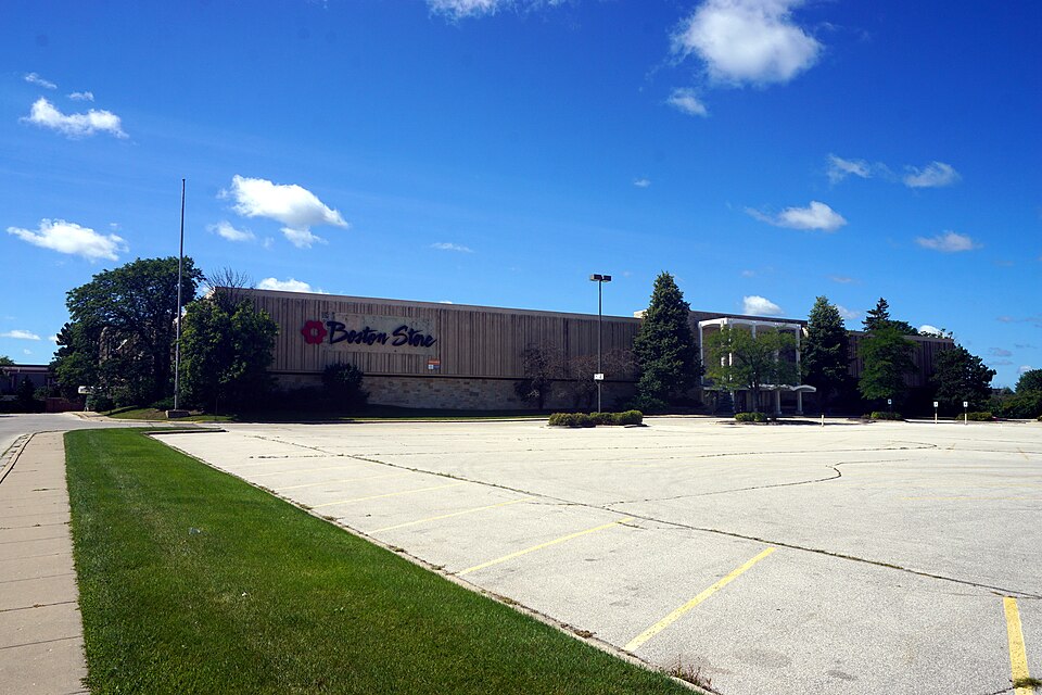
Northridge Mall was a shopping mall located in the northern part of Milwaukee, Wisconsin that first opened in August 1972. It was developed by Taubman Centers. The mall's original anchor stores were JCPenney, Sears, Boston Store, and Gimbels. Gimbels was sold to Marshall Field's, then H. C. Prange Co., and finally Younkers. The mall underwent a period of decline and was shuttered in 2003, and remained vacant until it was demolished in 2025.
Excerpt from Wikipedia (authors and history), CC BY-SA 4.0. May be older than the record above.
Timeline
- 1972 Grand opening
- 1973 Opened (Wikidata)
- 2003 Mall shuttered
- 2009 Value City furniture store closed
- 2013 Penzey announced plans to purchase mall
- 2014 Black Spruce retained ownership halting foreclosure
- 2018 Mall rented to MIR Tactical for airsoft event
- 2019 City issued demolition order
- 2020 Demolition order approved by judge
- 2022 Four arson fires occurred around mall
- 2024 Demolition of Boston Store portion began
Sources
- found by hermes-web (staffboxfree) · supports: acres, after notes, original developer, public subsidy, status, strategy, year closed
23 quoted sentences
was shuttered in 2003
the 58 acres (23 ha) of land the mall occupied remained vacant
It was developed by Taubman Centers.
As of 2026, the 58 acres (23 ha) of land the mall occupied remained vacant.
More in Wisconsin
 Brookfield Mall SearsBrookfield, WI · 2019Partial Redeveloped · Partial redevelopment, retail and entertainmentCenterpoint Marketplace MallStevens Point, WI · 2012Redeveloped · Redevelopment: education, new street
 Hilldale Shopping CenterMadison, WI · 2006Partial Redeveloped · Partial redevelopment: mixed-use residential, streetsPark Plaza MallOshkosh, WI · 2001Reinhabited · Reinhabitation, officeParkland MallMuskego, WI · 2016Redeveloped · Redevelopment: retail and residential